GPS Fleet Management Software Solution

Manage Your Entire Fleet From One Platform

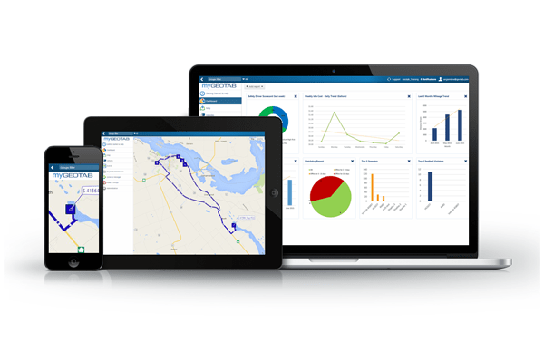
We offer a web-based GPS fleet management software solution; see all your driver and vehicle information in one place and use it to make quicker, better-informed decisions for your business.

Advanced Reporting

Advanced reporting flexibility makes managing your fleet easier. Start out with our standard reports, and make them more meaningful by tailoring them to your specific business needs. Easily gather, run and utilize the information you want the way you want it whenever you want it.

Manage Driver Behavior

Increase safe driving habits with in-vehicle driver feedback and coaching tools. Shared vehicles can still be individually identified with our Driver ID NFC technology.

Engine Data Reporting

Our devices collect and respond to common status information in your vehicle. This includes engine light, engine RPM, engine hours, seatbelt, odometer, emissions, vehicle battery voltage and vehicle identification number (VIN).

GPS Vehicle Tracking

See where your vehicles are in real-time or choose a custom date and look back to see where your vehicles have been. Our patented algorithms provide you with accurate and detailed trip information.

Route Optimization

Reduce vehicle mileage and fuel consumption through creating zones and routes for your drivers. Also, our GPS for fleets solution lets you compare actual routes versus planned routes.

Engine Health & Maintenance

Be alerted to potential critical engine health issues and easily prioritize repairs necessary for your vehicles. Detect issues early by focusing on proactive vehicle maintenance and setup vehicle maintenance reminders.

Open Data Integration

The open software development kit (SDK) allows you to integrate vehicle and location information into your company’s operations or with third party add-on/add-in applications.

Custom Mapping

Design your own business relevant maps which are automatically combined with the application’s vehicle information. Flexibility in map views, legends and zone shapes and sizes allow for further customization.

Source: http://www.geotab.com/fleet-management-software
Take A Closer Look At The ELD Geotab Drive

Electronic Logging Device: Geotab Drive


Update: Check out the most up to date post here: A Complete Guide to ELDs


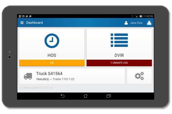
Geotab Drive is a savvy Hours of Service electronic logging device (ELD) and vehicle inspection application.

The FMCSA regulates commercial driving; they are getting ready to release a new set of rules in September, 2015. The regulation changes add clarity around the types of devices, how they are allowed to communicate, and what and how data is presented. These regulations have been debated and argued for the last several years leaving the rules to be highly anticipated.

It is expected in September 2015 fleets will need to switch from paper to electronic logs and Geotab is working hard to ensure the devices are fully in compliance with the new ELD rules. Depending on whether or not fleets are already using electronic logs or are still using paper logs, the transition period slightly differs. Any Commercial Motor Vehicle (CMV) has to transition from paper logs to ELD within 2 years after the release date of the new rules. Fleets using an AOBRD on the date of the release of the new regulations have 4 years to make the transition to the new ELD rules.

The Benefits of Geotab Drive
Geotab Drive is currently available on the Apple App Store and the Google Play Store. The application connects to the GPS GO Device in order to provide an automated process for creating accurate records of the drivers time spent in each duty status: On Duty Not Driving, Driving, Sleeper Berth, and Off Duty. The system is very user friendly and gives drivers more time to complete their daily tasks by simplifying the annoyance of always documenting their time. Through automating vehicle inspection reporting and driver logs, and depending on the number of duty status changes required by the driver to record, fleets are finding as much as an extra hour a day! That translates into lots of added productivity, not to mention the increased accuracy of the reports.

Where is it heading?
These features provide some amazing advantages to fleets, however the future of Geotab Drive is even more compelling. There will be support for two-way messaging for safe communication with the driver and ease of dispatch. Just like the MyGeotab software offers add-in ability to the base software, Geotab Drive will soon have the same functionality. This will allow end user fleets and other value added partners to add functionality directly into the Drive application.

For example, an add-in that shows a driver how many deliveries he made today on-time, based on his scheduling and routing software, or how closely he met the estimated miles on the projected route from the scheduling and routing program. Another option would be to provide the driver interface to a dispatch application where a driver has one application for all of his or her in-vehicle needs for HOS and dispatch.


Original Article By: Stephanie Voelker, Sales Manager at Geotab
http://www.geotab.com/blog/taking-look-geotab-drive/

Fleet Management Solution For Your Small Fleet


Small Fleet Management Solution


Productivity, Safety, Fleet Optimization, Compliance & Expandability make up the five pillar approach. This supports our ongoing innovation and assists businesses in making improvements in identified target areas. Each pillar offers a different way for businesses to save money and time. Unfortunately, many assume large fleets are the only ones to achieve significant savings; it’s important to recognize small to medium sized fleets can also reap these benefits.

How Small Are Small Fleets?

According to Frost and Sullivan, approximately 80% of fleets have under 10 vehicles, and most of these fleets do not have a fleet management solution (telematics). Also, it’s interesting to note that in order to be considered a “fleet”, a business must have bought 5 vehicles in a year and have a total of 15 vehicles in operation. In the June 2015 issue of Automotive Fleet, it’s explained that any commercial entities with under 15 vehicles are not considered to be a fleet.

Why Choose GoFleet & Geotab For Small Fleet Tracking?

1) Low initial investment

Some common initial expenses often associated with a new fleet management solution include: installation, testing, calibration and vehicle downtime during the setup process. Lucky for you, GoFleet & Geotab have made it as easy and low-cost as possible to get started. Geotab’s GO GPS devices are plug-and-play, not only do they eliminate install fees, but they also plug directly into the vehicle’s OBDII port, allowing for almost no downtime, and communication almost immediately after install. These benefits makes the Gofleet ideal small fleet management solution.

Minimal Entry Learning Curve

The learning curve involved in a barrier for any new tasks. Since a multi-tasking fleet manager is more likely for smaller fleets, although a fleet management solution may seem intriguing, finding enough time to properly utilize the solution may not seem achievable.

However, some of the features that can save you the most money (like in-cab driver alerts/coaching or maintenance warnings) are very quick and easy to learn and offer a high benefit-to-work ratio. For example, we frequently see our customers experience 5-10% fuel savings as a result of improved driver behavior alone, with other cases reaching beyond that. We also see savings of around 11% (but sometimes even up to 25%) on car insurance by adopting a small fleet management solution. Low initial investment combined with automated savings mean you’ll se a return on investment sooner than ever.

3) Ultimate flexibility and customization

On top of the many saving benefits, many small fleets are currently taking advantage of our customizable solution. There are thousands of compelling and unique ways to optimize and grow your business using our fleet management solution. For example, one of our current customers Boston Pizza, was looking for a solution to track their drivers. Not only did they gain real-time driver visibility, but with our solution they were also able to double the volume of their deliveries. Through the many add-ons we also have available, Excel reports, and the SDK, we are confident we can help you grow and better manager your business.

Our small fleet customers are able to save more than ever through our fleet management solution. We are also happy to offer weekly free training sessions and custom database configurations.


Original Article By: Jay Boychuk, European Solutions Engineer at Geotab
http://www.geotab.com/blog/telematics-untapped-breaking-barriers-small-fleets/

The Advancement of Telematics Technology

Telematics Technology


Your company is using Geotab’s GO devices and the MyGeotab software platform to manage your fleet, increase productivity levels, improve safety, and integrate data into other internal applications. It’s interesting to look back and see just how far telematics technology has changed and developed and how it will continue to change in the future.

Telematics of the Past

If we wind back the clock and look at how fleet management worked 10 years ago, we remember a very basic product with a GPS and position recorder. Back then an external antenna was required because GPS’s used to need direct view of the sky. Unfortunately, the external antenna was an obvious failure point. It had a long wire, connector, was always subject to interference, and was often the cause of needing installers to return to vehicles. Back then nobody was connecting into the vehicle’s OBD port. Because of this, intricate wiring had to be done in order to power the device, another failure point. Any time a wire was cut or a connection was made, the wire could break down. There was also absolutely no engine data available; for example there was no way to tell if a driver was wearing a seatbelt. Any fault lights and statuses or fuel data was completely unavailable.

Telematics Technology Device Connector

Old GPS devices had little to no expansion capabilities. They had dedicated I/O wires and possibly a serial port. Today we have come a long way from there and now have IOX expansion; there are over 30 different IOX’s that can be plugged into the Geotab GO device. Essentially, the wide variety of add-ons turns our tracking device into a very specialized data gathering computer. For example, a module that connects to the Iridium satellite network so that the device will work anywhere in the world, can be added at the same time as Mobileye integration, reefer temperature monitoring unit, and driver ID keys. The possibilities are almost endless.

Old devices were also missing an accelerometer. The accelerometer is an extremely sensitive micro machine (MEMS) that measures when you brake or accelerate too hard. It also has the capabilities to reconstruct what happened in an accident.

In the past, databases and software had to be installed in your own IT infrastructure. You also needed an expert staff member to manage the systems and install the end user software. Thankfully, today all systems are cloud-based through the web.

Initially, there were no API‘s for MyGeotab. Through the SDK, hundreds of partners are integrating data from MyGeotab into other systems like risk management, invoicing, maintenance, safety systems and route planning. There is an entire ecosystem of partners that are adding even more value to the existing Geotab solutions, in order to help customers solve business problems that are very specific to their industry that couldn’t be solved in the past.

It’s obvious new technology has brought amazing improvements to fleet management:

  • Reliability (no more cutting of wires, unreliable installs or mounting antennas)
  • Simplicity (plug & play installs in the OBD port, emailed reports, Web-based services, server rules & driver feedback)
  • New Engine Information (valuable measurements directly from the vehicle like ODO, seatbelt, fault codes & fuel consumption)
  • Expansion (new IOX’s that address virtually every use case, from weight scales to driver identification to temperature monitors)
  • API’s and Integration (automating data & connecting customers’ systems to solve any new tricky business problems)

Geotab GO Device Expansion

It’s truly amazing how far fleet management technology and telematics has come and how much it has improved fleet management. We will constantly continue to add value to how customers manage and measure their fleets.

The future holds a ton of exciting opportunities including connected vehicles, big data, and customer benchmarking.

GoFleet & Geotab are your partners at the FOREFRONT of changing fleet management. Between Geotab’s always improving technology and our incredible support staff and in house development team, we are sure to meet all custom needs to fit your business.


Original Article By: Niel Cawse, CEO at Geotab

http://www.geotab.com/blog/advancing-use-technology-telematics/

What to do if Your Engine Overheats

With the official first day of summer passing us by this weekend, it’s the time of year engine overheating becomes a much more prominent issue.

Increasing temperatures obviously mean a higher risk of your engine overheating; now is a great time to check out what steps you should take to respond to this should the problem arise.

The Florida Department of Transportation (FDOT) recommends if your vehicle does overheat, do not drive it more than a quarter mile further. It’s safer to have the vehicle towed to prevent more damage to the engine.

Of course, things do not always go as planned and you may not be able to get a tow truck or find a nearby mechanic. The FDOT suggests following these simple steps:

  • Find a safe location, pull over, and turn off the engine.
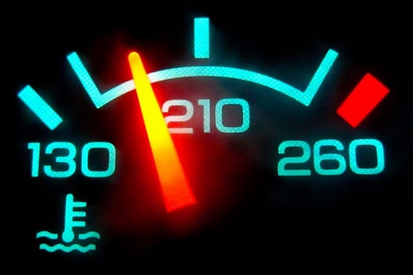
  • Let the vehicle completely cool or the make sure the temperature gauge has moved from hot to cool before opening up the hood.
  • Check the coolant, also known as antifreeze, level in the radiator; check the owner’s manual if you are not sure where the coolant reservoir tank is in the vehicle.
  • Before opening up the radiator cap, make sure it is cool, then slowly and carefully twist it off with a towel and watch out for hot steam. If needed, fill up the coolant to the top of the radiator and put the cap back on.
  • Make sure the upper or lower radiator hose and any of the heater hoses have not been disconnected, blocked or burst.
  • Restart the engine.
  • Keep an eye on the temperature gauge. If you noticed it crossing the optimal mark, find a safe location, pull over, and turn the engine off.

Getting help from a mechanic is always the best way to go, but sometimes you can’t always access one so it is important to be prepared. To stay safe, store these items in your vehicle: tool kit, coolant, non-perishable foods, water and a flashlight.

Source:
“Fleet Safety Video Tip: Engine Overheating.” Business Fleet. 2015 Business Fleet, 15/06/15. http://www.businessfleet.com/channel/safety-accident-management/news/story/2015/06/fleet-safety-video-tip-vehicle-overheating.aspx

Fuel Card Integration Saves You $$$


Fuel Card Integration from Fuel BI


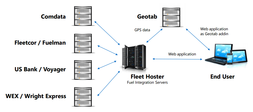
Fuel BI is an integration from our partner Fleet Hoster that uses the information Geotab GPS devices pull from the vehicle to cross reference with information collected from a Fuel Card.

When you’re operating a fleet, fuel cards and GPS devices can empower you to take control of your fleet fuel expenditures. With the Fuel BI integration, we will automatically capture your fleet card transactions, geocode them, process them against GPS data, and provide you the results in order to better analyze your fleet fuel expenditures. Fuel card integration will help you gain valuable insights with the following tools:

  • Built in Geotab security settings so your managers or users can only view the data they’re permitted to
  • Fuel expenditure charts and metrics over user selected periods of time
  • Location analysis with mapping of transaction and vehicle location at the time of purchase
  • Gain insight with transaction mapping on where your drivers are filling up
  • Capture gallons purchased vs gallons actually used with fuel consumption tracking
  • Customized user dashboard, alerts, and charts
  • Works with all 4 major fuel card providers

In order to provide our customers with the best information possible we pull data from both the fuel transaction and the vehicle’s GPS data. From each fuel transaction we can determine the transaction time, merchant location, product information, and driver identification. From the vehicle’s GPS data we can determine the log time, vehicle location, and vehicle status data.

fuel-card-main-alerts1
*The most important piece is the link between the fuel card provider and Geotab to identify a vehicle. A good match means that a link is successful.

fuel-card-main-alerts2
*We look for vehicle logs around the time of the transaction to get GPS data.

fuel-card-main-alerts3

fuel-card-main-alerts4
We look for an overall increasing fuel level trend around the time of the fuel transaction.

Our fuel card integration software helps you to gain an excellent overview of fuel expenditures and provide you with the tools necessary to pinpoint any suspected vehicles or transactions to prevent fuel theft.

fuel bi integration

With an easy setup process and easy to read key performance indicators you can start tracking your fuel purchases, referencing them with Geotab data, and saving money in no time.

How to Use Our Fleet Management Software for Dispatch

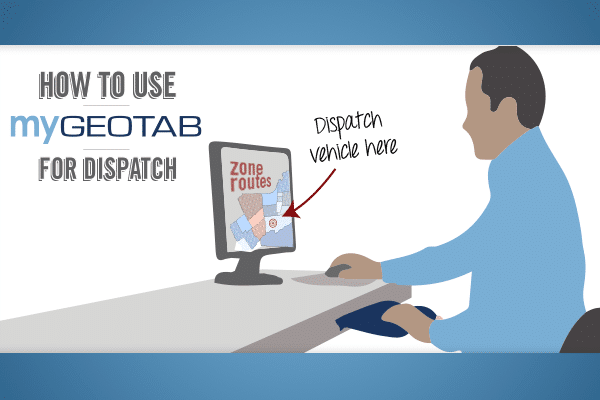
Our fleet management software offers an intuitive way to dispatch your vehicles to specified locations with the help of zones and third-party device integrations such as Garmin. Zones, as defined in our fleet management software My.Geotab, are geofences representing a virtual perimeter or fence around the geographical real-world area of interest. Dispatching within our software works by obtaining the zone addresses and then sending those addresses to a third parting routing device.


There are two main ways within My.Geotab of dispatching vehicles:
Dispatching Vehicles to Zones or Dispatching Routes to Vehicles.


Dispatching Vehicles to Zones
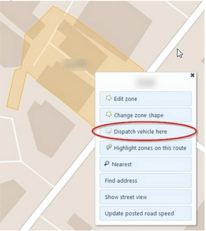
Before you can start dispatching vehicles to zones, you’ll need to add some zones first into your database. We offer simple tools for creating zones which allows you to easily draw a zone shape in the area you choose. Additionally, a large number of zones can be created all at once by importing a bulk list of longitude and latitude information in an Excel sheet. After the zones have been imported, you can then start dispatching to your vehicles by finding the zone on the map and clicking on it. By clicking on the zone it will open up a list of options including one called Dispatch Vehicle Here.

mygeotab dispatch gofleet

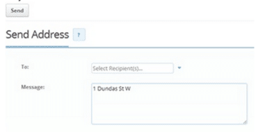
When clicking the dispatch button, you can select one or multiple vehicles that you would like to receive the request. In addition, a message can also be sent with the dispatch address which can be used to provide additional instructions for the driver. After the dispatch message has been sent, the routing device will receive the address and start routing to the destination as soon as the driver reads the message and chooses to accept the dispatch instructions.

mygeotab dispatch gofleet

Dispatching Routes to Vehicles
Entire routes can be sent to your vehicles to dispatch a series of destinations that your drivers should reach. Creating routes in MyGeotab can be done by simply connecting multiple zones together. To send a route to one of your vehicles, select Zones & Messages from the main menu within MyGeotab and then select Routes from the sub-menu. Find the desired route from the list of available routes, and then there will be an option to send the route to a vehicle.

mygeotab dispatch gofleet

Dispatching has been made easy with MyGeotab. It’s a powerful fleet management tool helping you enhance your overall customer service and fleet efficiency through creating custom zones. You will have better insight to where your vehicles are, and where your drivers are headed. This will allow you to see opportunities for fitting in more customer visits, while still reducing the number of miles driven. For more details about dispatching and zone creation, please refer to Geotab’s Product Guide.


Original Article By: Dominic Loong, Technical Services Engineer at Geotab
http://www.geotab.com/blog/use-mygeotab-dispatch/


Continuous Telematics Growth

The Golden Age of Telematics


Telematics is an ever expanding and exciting field involving multiple technologies simultaneously working together to collect and present data in a useful manner for cost-savings, process, standard improvements and safety. Telematics has been around for many years, however we are now entering the ‘Golden Age’ of telematics expansion, innovation, and growth.

Industry Trends

Increase in OEM Telematics

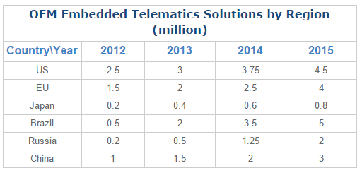
It is estimated that 15% of all vehicles sold across the world in 2014 were equipped with OEM embedded telematics. This number is expected to grow to 50% of all new vehicles sold by 2020.

Examples of OEM telematics include:

  • Roadside Assistance/eCall
  • Vehicle Diagnostics
  • Stolen Vehicle Tracking
  • Usage Based Insurance
  • WiFi Hotspot
  • Leasing & Rental Fleet Management
  • Connected Navigation & Infotainment
  • Convenience Applications
  • Electronic Road Charging

The number of new cars sold utilizing some sort of telematics is forecasted to increase from 7 million in 2013 to over 68 million in 2020. Embedded telematics systems are expected to grow from 8 million units sold in 2013 to 54 million units by 2020. That’s a Compound Annual Growth Rate (CAGR) of 31%.

Telematics Subscriptions on the Rise

Telematics service subscription numbers are expected to grow at a CAGR of 38%. This means the amount of subscriptions will rise from 16 million in 2013 to 158 million in 2020. In the near future, the global sales of insurance telematics products are projected to grow over 2013 to 2018 at a CAGR of 80%; in 2018 the subscriber base is expected to reach 85.5 million.


Worldwide Growth Potential

telematics growth chart geotab
(Berg Insight Forecasts)

The large growth expectation in the telematics market indicates that within the next 10 years, most of the cars on the road will be equipped with some form of telematics. In South Africa, the number of cars with a telematic system is projected to expand to 840,000 by 2017. There is an estimated 90% of the light consumer vehicles market which currently remains untapped. The Chinese telematics market is also expected to increase 22% at the end of 2014 from 2.1 million units to 5.9 million by 2019.


India’s Quickly Growing Telematics Market

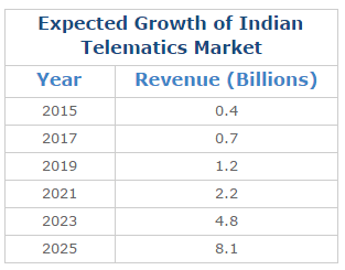
telematics growth chart india geotab
(Berg Insight Forecasts)

The Indian market is projected to grow at a CAGR of 31% (From 2015-2020) and CAGR of 38% (from 2020-2025).

Telematics and the Insurance Industry

A wide range of insurance companies have already begun to incorporate telematics into their policies, taking advantage of the huge data range collected by telematics devices in the following ways:

  • Pay As You Drive (PAYD): Monitor where, when and how often a vehicle is being driven. This technology can provide customized policies to suit each individual’s needs. It also can monitor unsafe driving habits and can be used to reward safe driving (deeper discounts, etc).
  • Accident Reconstruction: Determine the driver at fault during a car accident, decrease costs related to insurance fraud and gain quicker payouts to those injured
  • Vehicle Recovery: Track stolen vehicles for a better chance of quick vehicle recovery.

Check out this blog for further details on insurance discounts related to telematics devices.

Safety Benefits of Telematics Solutions

As telematics continues to advance, the benefits it can potentially provide will become even more significant. Google claims that with its driverless car technology, it will reduce the rate of traffic accidents by 90%, and Volvo claims by 2020 with its new cars it will provide an accident-free driving experience. While these benefits may be years away, telematics technologies offer multiple substantial benefits for fleet vehicles and personal vehicles alike, today.

Telematics is a tool to improve safety, boost employee morale, increase efficiency and add to the bottom line of any business. You do not want to get left behind! Get your fleet vehicles connected with telematics today! Contact us for more details so you can take advantage of the full benefits of telematics today and in the future years to come.


Original Article By: Boby Multani, Senior Technical Services Engineer at Geotab

http://www.geotab.com/blog/telematics-growth-the-golden-age/

How long is my GPS Data Stored with Geotab & GoFleet?

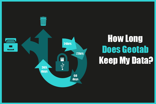
There are many people who store a significant amount of important and valuable information on their computer, such as financial documents, family movies and photos, personal music collections, and more. This large amount of data should be (but unfortunately, usually isn’t) backed up and preserved in case of data loss or theft. Each and every day there are millions and millions of data records passing through Getoab’s servers. This data is backed up in many different ways on a regular basis. This article will provide you with an in-depth explanation of how long the information is retained for and how frequently our Geotab data is backed up.

Active MyGeotab Databases
Databases currently in-use (with active Geotab GO devices, regular logins, etc.) are backed up on a nightly basis. Additionally, the previous 2 days of backups are also stored on a server in a different physical location. In the extremely unlikely event of the loss of a server, the previous nightly backups can be brought online.

Inactive MyGeotab Databases
In the effort to provide high server and because of the plethora of data stored in the MyGeotab servers, databases that are not in use are permanently removed from the servers after 60 days. A database not in use could be an empty database or one with all inactive devices.

Data Purging
Similar to the removal of inactive, empty databases to save valuable space, customer data older than one year will be regularly removed from the database. This purge, along with database deletion, is done without prior notice to customers.

How Can I Keep My Data for Longer?

Geotab GoFleet Management Software

Customers wishing to keep their data for longer than the guaranteed one year period are free to and encouraged to use our built-in migration tools for archiving their data.

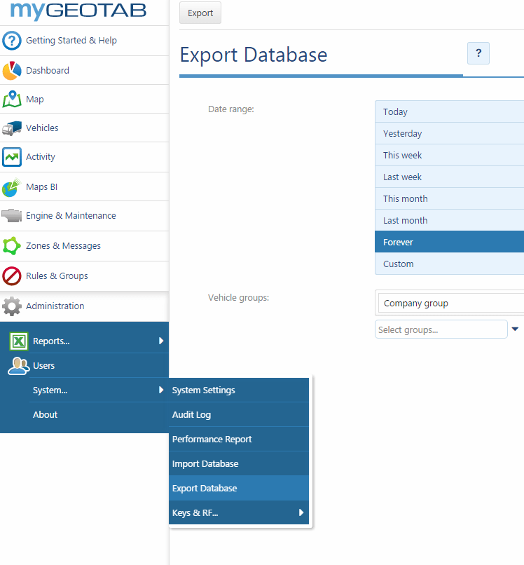
The current Export Database function in MyGeotab can be found by browsing to Administration, System, Export Database. It is here that you can control how much data is exported. Keep in mind that the database is suspended while it is being exported. Upon completion of an export, an email will be sent requesting the export with an attached .zip file containing the exported data.

In summary, Geotab is committed to taking care of your telematics data and providing outstanding uptime and data availability.

For more information on Geotab’s data retention and backup policies, please see our standard service-level agreement (SLA). For more information on MyGeotab database Export/Migration tools, contact us at 1-888-998-1122 or [email protected].


Original Article By: Phillip M.T. Rolle, IT Systems and Security Administrator at Geotab
http://www.geotab.com/blog/long-geotab-keep-data/


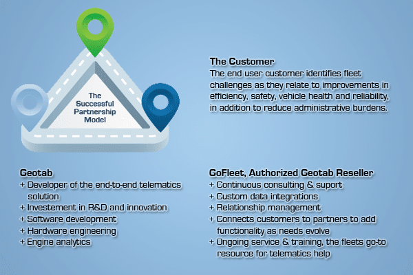
Why Choose GoFleet As Your Geotab Partner?


Finding the Right Geotab Partner


Geotab relies on a partner ecosystem to allow the technology they develop to be successfully represented, rolled out, and grow with ongoing customer needs. So how does a fleet choose which telematics provider is the best fit for their needs in the short AND long term?

Here is Geotab’s view of how to find out with a quick quiz:

Question 1
Will the information that is collected for your business be used by more than one department (fleet maintenance, fleet management, sales CRM, field force dispatch, risk management, claims management, government compliance, finance)?

Question 2
Is your IT team looking to standardize the various software programs needed to run a business today (payroll, CRM) along with some industry specific programs (route scheduling, IFTA)?

Question 3
Does your company have the in-house resources to watch the overall health of all deployed data collection telematics devices – ensuring uptime of all installed units?

Question 4
Does your company have the in-house analysts to inject your collected data into your company’s evolving business objectives?

If you answered yes to ANY of the 4 questions, Geotab may well be your best choice of a technology solution to rely on. If you answered yes and have already deployed with a different telematics provider, we would be happy to talk with you about making the switch. As a business, your freedom to operate and evolve is essential and that’s what the Geotab telematics operating system with GoFleet’s partnership approach is all about.

As a Geotab partner we resell their technology with additional applications and services; while also offering a business partnership approach and working with you on a regular basis. We take pride on never once having a customer who has not saved more money than our solution cost them and work closely with all our clients to ensure this high level of return on investment is maintained.

As an Authorized Geotab Reseller, we receive routine weekly training on best practices in deploying Geotab technology, business case studies, new features, and upcoming developments on the horizon. Geotab works with us daily to ensure our high level product knowledge and performance is maintained.

For businesses, there is a fog of telematics companies who on the surface appear to offer the same features and functions. But focus on the 4 questions and think of how together we will provide new business intelligence for you to use to grow and increase revenue.

Contact us to learn more about the partnership approach we take with each of our customers, and how we can generate the return on investment you are looking for.


Original Article By: Colin Sutherland, VP Sales & Marketing at Geotab
http://www.geotab.com/blog/finding-right-geotab-partner/