GPS Capabilities In Anklet Helps Juvenile Court System

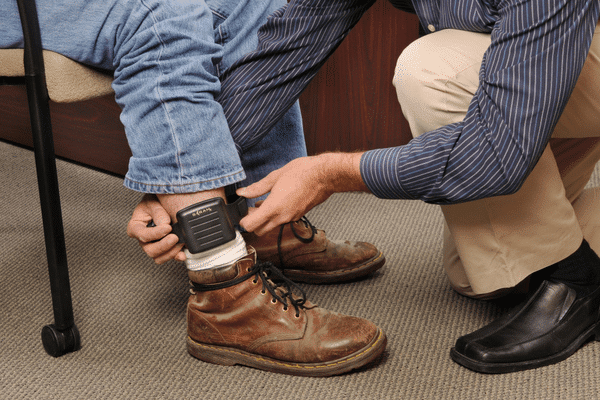
Anklet With GPS Capabilities Helps Juvenile Courts

As many people stop using landlines in their home, they are still a must-have for most people on house arrest. In Philadelphia, Pennsylvania, the juvenile system uses ankle bracelets that are really cell phones with GPS capabilities. Landlines are no longer necessary. It is a different story for non-violent offenders in the adult system, they still need this old telephone technology to serve house arrest. If the adults do not have a working landline at their home with no features including call waiting or DSL the do not qualify for house arrest.

These new house arrest devices with cell phone and GPS capabilities have other advantages also. For example, the young offenders can be monitored when they are approved to leave their house. The juvenile probation officers know where the juveniles are 24 hours a day – 7 days a week using the GPS capabilities of the ankle bracket. In addition, the juvenile probation officers can speak to the juvenile offenders via the GPS device with voice capabilities.

The ankle bracelet with GPS capabilities also has a software installed that can help solve crimes. If there is a high profile crime, shooting or any other crime in the area, the ankle bracelet with GPS capabilities can be used to put in a time and address from the crime to see if there were any youth that were in the area at the time of the crime.

In addition, the ankle bracelet with GPS capabilities has a locator that is an alarm that sounds like a police siren. If a juvenile offender violates the terms of his or her release, the siren will help authorities locate the offender if they are trying to hide. This is helpful if the offender is hiding in a large crowd or even in a home. The siren is so loud, the probation officers will have a much easier time locating a house-arrest violator.

GPS Monitoring Devices To Be Worn By Violent Offenders

Mother Pushes For Law To Require Violent Offenders to Wear GPS Monitoring Devices

Five years ago, a restraining order did not prevent Randall Todd Moore from sexually assaulting, kidnapping and shooting his wife who was separated from him, Terese Ann Lynch Moore. Now Terese’s mother, Sheila Lynch, is pushing for new law in Iowa. This law would require offenders ordered by a court to stay away from their victim to wear a GPS monitoring device. The electronic GPS monitoring device would alert the victim and local law enforcement if the offender got close.

Approximately 19 states currently have similar laws for violent offenders. Domestic violence is a real problem that needs a solution that works. In Iowa, Lynch argues, there is no solution. She believes if a law like this existed in Iowa and Randall Todd Moore was required to wear a GPS monitoring device, her daughter might still be alive.

Sheila Lynch states that it is hard for most people to understand how an offender can get to their victims. She said that her daughter stayed with her husband through years of abuse. Terese Ann was deployed to Iraq three times as a staff sergeant for the National Guard. When she met her husband, her demeanor and personality started to change. Previously a spunky woman, Terese became uncertain about herself and quiet.

Terese Ann Lynch was only 30 when her husband killed her. She would often urge people, including her mother, not to visit. Her mother noted that she felt like her daughter was sacrificing herself so her husband did not hurt anyone else.

After Terese Ann finally got a restraining order for her husband, he went to her apartment and kidnapped her. She had no idea that he was approaching her home. He sexually assaulted her and then fatally shot her in the face with a shotgun. When Moore was sentenced, he showed no remorse for what he did. He received three back-to-back life sentences. He also received 25 years for attempting to murder a Des Moines, Iowa police officer. If Moore had been wearing a GPS monitoring device, local officials and her daughter would have known he was approaching Terese’s apartment. Sheila Lynch wants a law on the books in Iowa requiring GPS monitoring device to be worn by offenders to help save other victims.

Global Positioning System Used To Monitor Vanishing Water

Vanishing Water Monitored With Global Positioning System

For years, small movements in the Earth’s crust have been monitored, using the Global Positioning System, to help provide warning of developing earthquakes. Researchers were surprised to discover that the GPS is also recording data in relation to the vanishing water in the western United States. Throughout the region, the landscape has been drying out massively due to the intense drought over the past year

Geophysicists from the Scripps Institution of Oceanography reported in Science Magazine that the GPS measurements indicate the loss of water from streams, lakes, groundwater, and snowpack total approximately 240 billion metric tons. This is the equivalent to 4 inches of water covering the western United States from the Pacific to the Rockies

The water loss measurement principle is simple. The weight of the Earth’s groundwater and surface water deforms Earth’s crust similar to the way a person’s weight deforms a mattress. When the water is removed, the Earth’s crust rebounds. The water levels on Earth vary with the seasons causing the Earth’s crust to move up and down. The movement is only fractions of an inch; however, the Global Positioning System is able to measure these small shifts

Since early 2013, researchers noticed that there has been a tremendous uplift signal (rise) in the Earth’s crust. The current uplift pattern is consistent with the declines in precipitation, groundwater levels and stream flow. Without the water, the Earth’s crust is elastically rebounding over the entire region

The Global Positioning System data complements observations from NASA’s satellites. NASA has an ongoing experiment, GRACE (Gravity Recovery and Climate Experiment), which is measuring small changes in the gravity field on Earth caused by water movement under and on the Earth’s surface. This experiment allows researchers to estimate soil moisture and groundwater conditions all over the world. The GRACE experiment is able to operate in areas around the world where Global Positioning Systems do not exist yet, such as South America and Africa

The new Global Positioning System data may prove vital as the climate changes worsen. This finding makes GPS data is useful to a wider group of scientists and researchers.

Vehicle Tracking System: Construction Company Fleets

Increase Profit In The Construction Industry With A Vehicle Tracking System

In order to have a successful construction company, you must run your business efficiently and show up at job sites on time. You rely on your construction fleet to make that happen. With GoFleet’s vehicle tracking system, you can stay ahead of your competition with valuable fleet management tools that will help you improve customer service, reduce costs, optimize your fleet’s productivity and ultimately increase your bottom line.

Reduce Labor Costs:

When you use GoFleet’s vehicle tracking system, you can improve dispatching and routing for your construction workers. By providing efficient routing, your workers will arrive at job sites earlier and spend less time on the road. In addition, you will know where your workers are at all times. You will not have to worry about a worker making authorized stops while they are on the clock. This improved productivity will reduce expensive overtime and labor costs.

Lower Fuel Consumption:

GoFleet’s vehicle tracking system provides your fleet managers with the tools they need to lower fuel consumption. For most companies with fleet operations, fuel costs are the single most expensive costs relating to the fleet. This cost can be reduced because fleet managers are able to monitor driving speeds, aggressive driving behavior and idle times, all of which increase fuel consumption.

Improve Customer Service:

When you use GoFleet’s vehicle tracking system in your construction fleet, you can drastically improve your customer service. Your customers will be astonished when your construction company actually shows up at the scheduled time. If a driver happens to be late, you will be able to let your customer know an accurate time of arrival. They will not be stuck waiting around for your construction workers to show up on the job site. Furthermore, your customers will be happy with the fast response time. With a vehicle tracking system, you are able to send the closest workers to your customers’ locations.

Vehicle GPS Tracking System: Government Businesses

Government Businesses Benefit From Implementing a Vehicle GPS Tracking System

Government fleet managers have to deal with government mandates on fleet utilization and size, budget cuts and aggressive goals to reduce emissions. A vehicle GPS tracking system helps government businesses meet these challenges by optimizing your fleet size, decreasing operational costs, reducing emissions, deterring vehicle theft and helping you achieve your fleet management goals.

Vehicle GPS tracking systems will provide your government business with the data you need to fully understand your fleet’s performance and the tools you need to improve it.

Reduce Labor Costs

Improved routing and dispatching minimizes the time your drivers are on the road, improves response times and helps you to prevent expensive overtime. Most government businesses see a reduction in labor costs only months after implementing GoFleet’s vehicle GPS tracking system.

Decreased Fuel Consumption

Monitoring your drivers’ speed, aggressive driving habits and idle time can be used to decrease your fuel consumption and costs. This is often the largest expense for a government fleet.

Optimize Fleet Performance And Size

When you are able to completely analyze your fleet’s performance including miles driven, days utilized, peak usage and average usage, you will be able to optimize your fleet’s performance. There are many customizable features that let you track each vehicle by location, site or department. This information will allow you to make the most informed business decisions regarding vehicle utilization and fleet size.

Deter Vehicle Theft And Any Unauthorized Use

When you use GoFleet’s vehicle GPS tracking system, you will not only deter theft, you will eliminate unauthorized usage of government vehicles. If your drivers drive off-route or use the vehicle during personal time, your fleet manager will be immediately notified. Drivers will no longer be wasting time and fuel driving off-route to get a bite to eat or a cup of coffee. This will improve your customer response times and reduce labor and fuel costs.

For more information about how GoFleet’s vehicle GPS tracking system can help your government business, Contact Us.

GPS Used To Enhance Experience At Cuyahoga Valley National Park

Cuyahoga Valley National Park Uses GPS To Enhance Experience

According to Cleveland.com, Cuyahoga Valley National Park will soon use GPS to provide a virtual park ranger on visitors’ smartphones. Researchers at Kent State University have received a National Science Foundation grant in the amount of $952,000. This grant is to be used to create a free mobile application for the park with many interactive features including information about the park’s history, geology, scientific park features, and habitat.

Park visitors will be able to log in anonymously and provide valuable information to the park scientists and rangers to help them learn more about Cuyahoga Valley National Park’s ecosystem. They will also be able to save specific information about their park experiences. Visitors will be able to easily interact with the park staff from the convenience of their mobile device. The park staff will also be able to see the visitor’s exact location via GPS in the event they need help.

There are other mobile applications with information about the national and local parks; however, none of them have nearly as much detail as the proposed application. It is more of an augmented reality then a virtual tour. It provides many tools that will enhance the visitors’ experience. The prototype should be ready within 6 months and the application should be fully functioning within a year. The application could eventually be used by parks around the world after they build the databases of content.

As part of this project, funding will also be provided to Cuyahoga Valley National Park for 2 seasonal employees that will help implement and test the new mobile application using GPS data. The users will be surveyed to find out what they learned, their interests and their attitude on personal learning. There are over 2.5 million people who visit the Cuyahoga Valley National Park each year. The visitors make approximately 11,000 requests for information about park resources and wildlife. The new app should reduce the number of requests because visitors will have all the information at their fingertips.

GPS Technology: Helps Emergency Responders

Response Time Improved For Emergency Responders Using GPS Technology

GPS technology is being used in the Ozark foothills to help emergency responders. Frank Wideman, a natural resource engineer at the University of Missouri, teaches the responders how to use GPS technology to provide faster emergency services in Madison and Iron counties.

The GPS technology is being used to help the volunteer firefighters locate the 300 local fire hydrants. A local Boy Scout troop worked with the town’s volunteers to locate and save the location information of all the fire hydrants in the Global Positioning System map. This is extremely helpful because it is hard for the volunteers to be able to know the exact location of all the fire hydrants in the area.

When the emergency responders are dispatched, the GPS location information is sent electronically to the firefighters. The information includes the emergency location, the nearest fire hydrants and individual fire hydrant information. The GPS technology system shaves off minutes of critical emergency response time because the volunteer firefighters are not stopping to ask residents where the hydrants are or searching through paperwork for fire hydrant locations.

It is important that the fire fighters know where the fire hydrants are located because they need to quickly determine the length of the hose, the pumping capability and the type of connector needed. The information that was gathered by the local Boy Scouts about each fire hydrant includes the installation date and the manufacturer. This information is also helpful to officials for replacement and maintenance decisions.

The GPS technology is also being used to help search and rescue teams find lost or stranded campers, hikers and boaters visiting the mountains. Many of the area’s steep canyon trails are only accessible by foot and are unlit. Cell phones send the GPS signals to the emergency dispatch team. Responders are able to find the people despite the darkness and rugged terrain. According to Democrat News, the GPS technology has cut search and rescue times by approximately 75%.

Using the GPS technology for emergency responder services also saves property owners in the area money. The shorter response times in the event of a fire, lowers the Insurance Service Office ratings (ISO ratings). Risk experts rate the quality of the fire protection services in the area. The lower ISO ratings equal lower insurance premiums for the local property owners. When the GPS technology was implemented for emergency services in the Ozark foothills, the ISO rating decreased 3 points on a 10 point scale.

Real Time Tracking Devices: Pest Control Companies

Pest Control Companies Use Real Time Tracking Devices To Manage Fleet

Your pest control technicians are servicing your clients all day long and you need to keep track on their activity. GoFleet’s real time tracking devices can make your fleet of pest control vehicles more efficient, improve customer service and reduce fleet-related costs.

GoFleet’s real time tracking devices can give you the competitive advantage you need to increase business. You will be able to provide your clients with accurate estimated times of arrivals and short service windows. Your clients will not be stuck waiting all day for your pest control technicians to arrive on site. You will be able to tell your clients with confidence that your technician will arrive within 30 to 40 minutes. Your pest control clients will be so impressed by the high level of customer service they receive.

When you implement GoFleet’s real time tracking devices in your vehicles, you will gain valuable information about your fleet operations that can help you make more informed business decisions. GoFleet empowers pest control companies with detailed routing and dispatching tools.

In addition to knowing where your vehicles are located, you will find out information about your technicians’ driving habits. If your drivers drive aggressively, idles excessively or speeds, you can get notified with instant alerts even when you are offline. The alerts can be sent directly to your cell phone via SMS text messaging or email. This will ensure your technicians are driving safely and representing you professionally on the road.

GoFleet’s real time tracking devices can be fully integrated with a wide variety of pest control software packages. This allows you to simplify dispatching and run the most efficient operations. GoFleet helps you get the most out of your technicians and fleet assets. For more information about GoFleet’s pest control company services, Contact Us.

police - GPS monitoring device

GPS Monitoring Device Used To Protect Domestic Violence Victims

Domestic Violence Victims Have GPS Monitoring Device Option

In Memphis, Tennessee, a GPS monitoring device can be used to notify a domestic violence victim that they might be in harm’s way. Many believe that if more domestic violence victims knew about this option, many tragic cases might not have ended as badly.

All domestic violence victims have to do is petition the court to use the GPS monitoring device on the perpetrator. The problem: many victims to not know GPS monitoring is an option. The court system and law enforcement agencies need to do a better job at educating domestic violence victims about what their options are to keep them safe.

Lawmakers are saying that if Charles Thomas was required to wear a GPS monitoring device, Tasha Thomas might still be alive today. On Tuesday, day care worker Tasha Thomas was outside of work when Charles Thomas, her husband, approached. All she had was a restraining order against her husband. The day ended in tragedy when murder-suicide left both Tasha and Charles dead.

According to Tennessee state law, Charles Thomas could have been forced to wear the GPS monitoring device. This device would have alerted Tasha Thomas by SMS text message when her husband was approaching and danger was near. The device would have also alerted the local police. The police would have been sent to the scene as soon as her husband was close by Tasha’s job. The entire tragedy could have been prevented.

Because many domestic violence victims are unaware of this option, a domestic violence victim lost her life and her children lost both of their parents.

Domestic violence victims need to seek help from local agencies to find out what other options are available to them in addition to just filing a restraining order. A restraining order is just a piece of paper and does not guarantee anyone’s safety. Victims need to devise a safety plan and know what their rights are. For more information about domestic violence visit the National Coalition Against Domestic Violence.

GPS Fleet Monitoring: Benefits Tow Truck Companies

Tow Truck Companies Benefit From GoFleet’s GPS Fleet Monitoring

When you are in the towing business, it is crucial that you stay on top of the upcoming jobs using GoFleet’s GPS fleet monitoring GPS fleet monitoring. You need to make sure your drivers are at the job site in a timely manner to ensure your business runs efficiently. This translates into more business.

Many customers assume when they call a tow truck company that they will be stuck waiting for service for an indefinite amount of time. When you use GoFleet’s GPS fleet monitoring, you will be able to change all of that for them. You will be able to dispatch the closest tow truck to the driver’s location using the fastest and shortest route.

You will also be able to provide your customers with a short service window and an accurate estimated time of arrival. If you have a tow truck close by your customer’s vehicle, you will be able to tell your customer “Your tow truck driver will arrive within 10 minutes.” Your customers will be blown away by the level of customer service they receive when they call your tow truck company. Word of this type of high quality service travels fast. You will have many more customers before you know it. Furthermore, the improved customer satisfaction will help you retain more clients and develop loyal long-term relationships.

In the towing business, it is not just about towing a car, fixing a flat tire, charging a battery or recovering a car. This business relies on prompt service, location accuracy and route flexibility. Many of your customers are calling you for service because they are stuck on the side of the road or in an unknown location. These circumstances can be dangerous. Your customers are relying on you to come to their aid as fast as possible and get them back on the road safely.

GoFleet’s GPS fleet monitoring can raise your tow truck company’s game by ensuring fast response times and more efficient route planning. This can mean huge fuel savings, improved customer services and high productivity.